How Helsinki is expanding using digitalisation to foster functionality for its residents. By David Huie.
The City of Helsinki has been working to become the most functional city in the world by digitalising all aspects of its planning, construction, and maintenance.
Located on a peninsula in the Gulf of Finland, Helsinki has centuries of architecture that require maintenance as it continues to expand in a sustainable way.
This article was originally published in Smart Energy International Issue 4-2021.
Read the mobile-friendly digital magazine or subscribe to receive a print copy
In 2013, the city began by searching for a project and document management system and proven processes to replace its manual operating practices. So, they deployed a connected data environment as the backbone of the new operational control system for projects, creating a solid framework for document management, efficient information sharing, and work collaboration across project teams.
Then, in 2016, they continued their mission to become a model digital city by producing a 3D-representation of the city to improve Helsinki’s internal services and processes, promote smart city development, and share city models as open data to citizens and companies for research and development.
The use of reality modelling software significantly lowered the cost of making the reality mesh model of the city and the semantic city information model. The interoperable modelling applications provided the City of Helsinki with the ability to implement smart city development, advanced city analyses, and the opportunity to participate in frontline progress.
Now, with the Helsinki Digital City Synergy project, they seek to realise the practical and versatile benefits of these models while bringing more value from them by creating a citywide digital twin. To complete this ongoing project, they realised that they would need to integrate and utilise their models to support internal processes and public services, as well as continue to support strategic goals for a sustainable, smart city.
The City of Helsinki employed three organisations to work together to achieve its goals. Helsinki City Environment Division is responsible for the strategic and detailed planning, traffic and street planning, land property development, and urban space and landscape planning. They are also responsible for city survey, asset management, housing production, city and corporate services, and building control.
Helsinki 3D+ is responsible for creating the 3D models and maintaining the digital twins with the latest information. They develop open data services and support integrating new technology for better processes and services. Forum Virium Helsinki is a city-owned innovation company that works with companies, universities, other public sector organisations, and city residents to promote urban development and digitalisation.
Improving collaboration with digital workflows
Helsinki City Environment Division, Helsinki 3D+, and Forum Virium Helsinki knew that they wanted to integrate the existing models with the data from their internal processes and public services. They needed to use models to engage residents, utilise open data models for public-private co-innovation, and support both smart city and sustainable carbon neutral goals.
However, they would first need to overcome any technology and collaboration challenges. The City of Helsinki is 500 square kilometres, and the entire city would need to be modelled with all asset data implemented. They also needed to ensure that they could freely share the results with the public, as well as encourage them to join the effort. Therefore, they needed an open digital city platform for their digital twin.
Digitalising Helsinki with a digital twin
Already having used them to create their city models, the City of Helsinki once again chose to use Bentley applications to complete their Digital City Synergy project.
The Helsinki City Environment Division used MicroStation, ContextCapture, and OpenCities Map with a reality mesh and information model of the 500-square kilometres city area for their digital twin, which includes their CityGML. They also used ProjectWise to establish a connected data environment. OpenCities Planner was the visualisation and collaboration platform for all stakeholders, including the public.
Helsinki 3D+ continues to use MicroStation, ContextCapture, and OpenCities Map to create and maintain the entire city reality and information models. Additionally, laser scanning and oblique photogrammetry ensure that the models of the city consider surface and terrain details. The applications also provide consistency between the two models, vital to having reliable data. They also use LumenRT to produce their own video clips to share with all stakeholders and the public. OpenCities Planner allows city leaders and decision makers to better visualise the infrastructure, improving understanding of projects and overall organisation. With Helsinki’s open data policy, the Helsinki 3D+ team supports many use cases, including analysing solar power utilisation, conducting flood assessments, and performing noise calculations, as well as allowing third-party developers and universities to access and use data for additional projects.
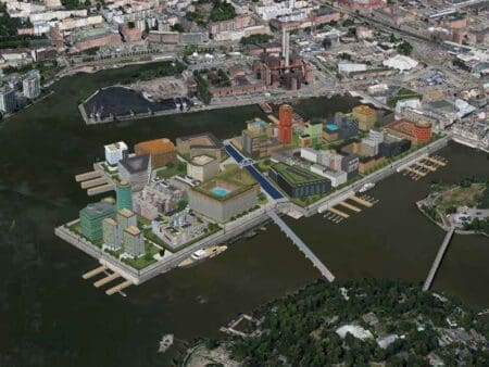
Meanwhile, Forum Virium Helsinki expanded on Helsinki 3D+’s digital twin, focusing on Kalasatama — a neighbourhood in Helsinki — by using Bentley applications. They wanted to see how this expanded digital twin could help them advance a large urban development project. They analysed and collected data for green infrastructure to help the city meet its net-zero carbon goals by 2035.
The need for this type of infrastructure has also become more important than ever during the COVID-19 pandemic. Called SmartKalasatama, this platform was based on OpenCities Planner to present smart city solutions, acting as a starting point for visualising and communicating all projects throughout Helsinki before actual implementation. It also helped facilitate citizen participation, providing an easily accessible, highly visual environment where stakeholders, including current and potential Kalasatama residents, could view the project information and give input — even from mobile devices. The platform is now a model for the rest of the city to follow for future development projects and showing how digital twins can continually grow as the needs of the city grow over time.
Bringing stakeholders and citizens together with open data access
The City of Helsinki’s open, digital solution enables better decision-making by connecting the right information to the right stakeholder. The solution also allows designers to evaluate different plans and the impact of those plans on the city before construction. When seeking permits, all the information is available directly in the model to make the process easier and smoother. Smart city solutions allow for an improved quality of life for residents, such as by making sure that construction is less disruptive and greener. With open access to data from the entire city, the public can access the same information as project stakeholders, providing transparency and improving public relations.
Currently, Helsinki’s City models are being streamed into video games like Minecraft Helsinki. This situation is beneficial because it will get young people interested in city models in infrastructure, as well as promote tourism to Helsinki once it is safe to travel. The data is already being used by universities and research institutions, with its city models being the second most popular downloaded data sets.
Overall, the city of Helsinki is providing a reliable digitalised data infrastructure to support sustainable smart city initiatives, creating a better quality of life for its citizens and visitors. Moving forward, they will continue to expand their digitalisation efforts to create their citywide digital twin.
About the author
David Huie is Senior Product Marketing Manager for Modelling and Visualisation at Bentley Systems.